Radar Measurements and Predictions
OSAPOL Radar Measurements
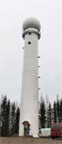
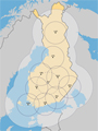
- 9 C-band Doppler Radars (8 with dual polarization)
- Data utilization rate 98.5 % incl. maintenance and telecommunications
- 9 x 500 x 360 = 1620000 measurements with one sweeps
- whole Finland with resolution 5min/1 km².
Benefit of Radar Measurements
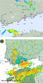
Convective systems often small and short living (5 km, 1 h). Only weather radars have the needed resolution for measuring the time-space pattern s of rain generating storm water flooding. Weather radar is not as accurate as a rain gauge. With radar measurements reasonable predictions are possible.
Seamless Rainfall Prediction
0-2 h (0-6 h) prediction is based on movement vectors of rainfall obtained from radars. 2 h ? 15 d forecasting is based on numerical weather prediction models (HIRLAM/ECMWF). Seamless blending of the different sources is a recent development. Pilot projects:
- Tekes/RAVAKE, 2009-12 and
- EU HAREN & EDHIT 2012-2015
Spatially Accurate Prediction
Numerical weather prediction models are reasonable good regionally. In urban scale radar predictions are more precise. For optimization and risk management of rain water impacts probabilistic predictions are more beneficial than single predictions (deterministic). Ensemble Prediction Systems (EPS) will provide such estimates.
- FMI: 51 members of ensemble forecasts (Koistinen et al. 2012)